Sydney West

Bushwalks in the Blue Mountains National Park.

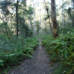
The Blue Mountains region offers numerous bushwalks, mountain bike trail, lookouts, waterfalls and scenic drives. Walking tracks with lookouts, canyons, streams and waterfalls are scattered all over the region.

Below are some of trailmaze’s recommendations for the best bushwalks in the Blue Mountains.

Wentworth Falls, Blue Mountains

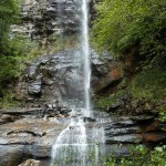
Wentworth Falls, Blue Mountains:

Distance: 5km, also shorter walks.
Difficulty: Hard
Rating: 5 Stars
Location: Blue Mountains

Read More ->

Vera Falls, Blue Mountains

Vera Falls, Blue Mountains

Distance: 7km return.
Difficulty: Expert only
Rating: 4 Stars
Location: Blue Mountains
Giant Staircase, Blue Mountains

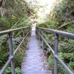
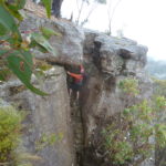
Giant Staircase, Blue Mountains

Distance: 6km circuit.
Difficulty: Hard
Rating: 5 Stars
Location: Blue Mountains


Grand Canyon Walking Track, Blue Mountains

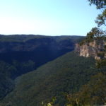
Grand Canyon Walking Track, Blue Mountains

Distance: 6.3km loop.
Difficulty: Hard
Rating: 5 Stars
Location: Blue Mountains
Ruined Castle Blue Mountains

Ruined Castle Blue Mountains

Distance: 8km return.
Difficulty: Hard.
Rating: 4 Stars
Location: Blue Mountains.

Read More ->

Tarros Ladders

Narrow Neck Blue Mountains.

Distance: 20km return.
Difficulty: Medium.
Rating: 5 Stars

Location: Blue Mountains.

Read More ->

Deep Pass

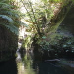
Deep Pass, Newnes

Distance: 4km loop.
Difficulty: Hard
Rating: 5 Stars
Location: North of Blue Mountains
Hanging Rock, Blue Mountains

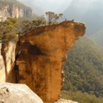
Hanging Rock, Blue Mountains

Distance: 12km return.
Difficulty: Meduim
Rating: 5 Stars
Location: Blue Mountains
Blue Gum Swamp, Blue Mountains

Blue Gum Swamp, Blue Mountains

Distance: 9km loop.
Difficulty: Meduim
Rating: 5 Stars
Location: Blue Mountains

Map of the best Blue Mountain Bushwalks.

The map below contain some of the best bushwalks in the Blue Mountains region.

Export as KML for Google Earth/Google MapsOpen standalone map in fullscreen modeCreate QR code image for standalone map in fullscreen modeExport as GeoJSONExport as GeoRSS
Bushwalk - NSW - West

loading map - please wait...

Wentworth Falls waterfall: -33.727554, 150.374202
Vera Falls, Blue Mountains: -33.720234, 150.362675
Inspiration Point: -33.723483, 150.352161
Giant Staircase: -33.731514, 150.312152
Ruined Castle: -33.734025, 150.282595
Grand Canyon, Blue Mountains.: -33.646600, 150.325241
Narrow Neck Bushwalk: -33.754852, 150.270181
Deep Pass Canyon: -33.340270, 150.299375
marker icon
Get directions Open standalone map in fullscreen mode Export as KML for Google Earth/Google Maps
Wentworth Falls waterfall

Wentworth Falls waterfall, Blue Mountains.

Wentworth Falls offers numerous walking tracks ranging from easy to difficult, 1km to 10km.

Wentworth Falls waterfall snapshot:

Distance: Various walks. Distance ranges from 700m to 10km circuit.
Where: Trail head, end of Falls Rd, Wentworth Falls, Blue Mountains.
Difficult: Short walks are easy. The larger walks are graded hard.
Rating: 5 stars

Wentworth Falls Lookout, New South Wales, Australia
marker icon
Get directions Open standalone map in fullscreen mode Export as KML for Google Earth/Google Maps
Vera Falls, Blue Mountains

Vera Falls, Blue Mountains.

Vera Falls, Blue Mountains Snaphot:
Distance: 7km return
Where: Trail head, Conservation Hut, Wentworth Falls
Difficult: Only for experienced Bush walkers. Hard.
Rating: 4 Star

Vera Falls Track, New South Wales, Australia
marker icon
Get directions Open standalone map in fullscreen mode Export as KML for Google Earth/Google Maps
Inspiration Point

Inspiration Point, Blue Mountains.

Inspiration Point, Blue Mountains. This site has directions, maps.

Inspiration Point snapshot:
Distance: 3-4km’s return.
Where: Blue mountains, near Fairmont Resort.
Difficulty: Easy.
Rating: 4 Starts

marker icon
Get directions Open standalone map in fullscreen mode Export as KML for Google Earth/Google Maps
Giant Staircase

Giant Staircase.

Giant Staircase loop, Blue Mountains snapshot:

Distance: 6km loop.
Where: Echo Point lookout, Blue Mountains.
Difficulty: Hard.
Rating: 5 Stars

Katoomba New South Wales, Australia
marker icon
Get directions Open standalone map in fullscreen mode Export as KML for Google Earth/Google Maps
Ruined Castle

Ruined Castle Blue Mountains.

Ruined Castle Bushwalk snapshot:
Distance: 8km return.
Where: Golden Stairs.
Difficulty: Hard.
Rating: 4 Stars

marker icon
Get directions Open standalone map in fullscreen mode Export as KML for Google Earth/Google Maps
Grand Canyon, Blue Mountains.

Grand Canyon Walking Track, Blue Mountains.

Grand Canyon Walking Track, Blue Mountains snapshot:
Distance: 6.3km loop.
Where: Evans Lookout, Blue Mountains.
Difficulty: Hard.
Rating: 5 Stars

Evans Lookout Road New South Wales, Australia
marker icon
Get directions Open standalone map in fullscreen mode Export as KML for Google Earth/Google Maps
Narrow Neck Bushwalk

Narrow Neck bushwalk.

Narrow Neck Bushwalk snapshot:

Distance: 20km return.
Where: Katoomba, Blue Mountains.
Difficulty: Medium.
Rating: 5 Stars

Narrow Neck Lookout, Katoomba, Australia
marker icon
Get directions Open standalone map in fullscreen mode Export as KML for Google Earth/Google Maps
Deep Pass Canyon

Deep Pass Canyon

Deep Pass Canyon:

Distance: 4km loop.
Where: Newnes, North of Blue Mountains.
Difficulty: Hard.
Rating: 5 Stars

Glow Worm Tunnel Road New South Wales, Australia

Tags:

Blue Mountains, bushwalks, bush walks, hikes, trek, hiking, top 10 bushwalks Blue Mountains, Trails, tracks, blue mountain bushwalks, best blue mountains bushwalks, trails, tracks.

Submit your review
1
2
3
4
5
Submit
     
Cancel

Create your own review

Trail Maze
Average rating:  
 0 reviews