Sydney North
NSW Sydney North bushwalks
Sydney North, NSW has numerous bushwalks ranging from large hikes to short walks. Ku-ring-gai Chase National Park is well worth a visit.
Trailmaze’s Best Bushwalks on the North Side of Sydney.
Below is a list of trailmaze’s best hikes North of Sydney:
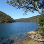
![]() Apple Tree Bay
Distance: 10km return
Difficulty: Medium. Rating: 4 Stars Location: Sydney North
|
||
To assist you with navigating the web-site I have included the following:
- A menu bar broken into States and regions of the state.
- A side bar on the right which contain quick links for you to click on.
- A scale-able map where you can zoom in and out to find the region your after. Once found click on the walk and it contains a link to the page that has the details on the bushwalk.
- The bottom of each map contains all the bushwalks with a very brief description and a link to the page with the details about the walk.
So there are a variety of ways to find the walk your after. At the moment most of the walks are focused on New South Wales. I’ll start to update more walks around the country.
The map below contains some excellent walks to explore. Use the plus and minus icons to zoom in and out on the map.
Hope you find the information you were after.
loading map - please wait...
![]() | Anice Falls, Royal National Park Anice Falls, Royal National Park Distance: 8km return Where: Trail head just off Costen Point fire trail Difficulty: meduim/hard Rating: 3 1/2 stars Mount Bass Fire Trail, Royal National Park, New South Wales, Australia |
![]() | Bundeena Coastal Track Bundeena Coastal Walk Jibbon Beach, New South Wales, Australia |
![]() | Figure 8 Pools Figure 8 Pools. Royal National Park
Figure 8 Pool, Royal National Park Trail, Lilyvale, New South Wales, Australia |
![]() | Fitzroy Falls Fitzroy Falls, Morton National Park Distance: 4km – West Rim track Distance: 7km – East Rim track Fitzroy Falls, New South Wales, Australia |
![]() | Forest Island, Royal National Park Forest Island, Royal National Park Distance: 14km from Waterfall station, 4.5km from end of Lady Carrington Drive Difficultly: Easy from end of Lady Carrington. Difficult from Waterfall station. Rating: 5 stars Where: At the end of Lady Carrington Drive in the RNP Lady Carrington Drive, Royal National Park, New South Wales, Australia |
![]() | Audley to Engadine, Royal National Park Distance: 10km Difficulty: Hard at the start of Grays Point. Medium from there on. Where: Next to Grays Point public school. Or start at Audley in the Royal National Park. Rating: 4 Stars Audley Weir, Sir Bertram Stevens Drive, Royal National Park, New South Wales, Australia |
![]() | Karloo Pools, Royal National Park Distance: 4km return walk Where: Back of Heathcote Station Difficulty: Medium Rating: 5 Stars Karloo Pools, Royal National Park, New South Wales, Australia |
![]() | Kurnell, Botany Bay National Park Kurnell Cliffs Where: Botany Bay, National Park. Cape Solander Distance: 8km return Difficulty: Easy to meduim Rating: 4 stars Kamay Botany Bay National Park, Kurnell, New South Wales, Australia |
![]() | Uloola Falls, Royal National Park Uloola Falls, Royal National Park Uloola Falls Bush Campground, Wollongong, New South Wales, Australia |
![]() | Wedding Cake Rock, Royal National Park Wedding Cake Rock, Royal National Park Where: Trail head, Bundeena end of Beachcomber Avenue. Distance: 6km return Difficulty: Medium Rating: 5 stars Wedding Cake Rock, New South Wales, Australia |
![]() | Winifred Falls, Royal National Park Winifred Falls, Royal National Park Where: Trail head, Warumbul Rd, Royal National Park. Distance: 3km return Difficulty: Medium Rating: 4 stars Winifred Falls Trail, Royal National Park, New South Wales, Australia |
![]() | Wentworth Falls waterfall Wentworth Falls waterfall, Blue Mountains. Wentworth Falls Lookout, New South Wales, Australia |
![]() | Vera Falls, Blue Mountains Vera Falls, Blue Mountains. Vera Falls Track, New South Wales, Australia |
![]() | Wattamolla to Big Marley Wattamolla to Big Marley Distance: Just over 10km Where: Tail head is from Mattamolla car park near the waterfall. Difficulty: Medium. Rating: 4 Stars Wattamolla Beach, Wollongong, New South Wales, Australia |
![]() | Wattamolla to Eagle Rock Wattamolla to Eagle Rock. Distance: Approximately 7.5km return Where: Trail head is south of Wattamolla Difficulty: Medium Rating: 5 Stars Wattamolla Picnic Carpark, Wattamolla Road, New South Wales, Australia |
![]() | Garie Beach to Eagle Rock Garie Beach to Eagle Rock Garie Beach, Wollongong, New South Wales, Australia |
![]() | Inspiration Point Inspiration Point, Blue Mountains. |
![]() | Bundanoon - Glow Worm Glen Bundanoon – Glow Worm Glen snapshot: Glow Worm Glen Walk, Bundanoon, New South Wales, Australia |
![]() | Belmore Falls Belmore Falls - Morton National Park Hindmarsh Lookout Track, Barrengarry, New South Wales, Australia |
![]() | Bundanoon - Creek Track Bundanoon Creek walking track Bundanoon Creek Walking Track, Bundanoon, New South Wales, Australia |
![]() | Bungonia National Park Lookouts Bungonia National Park Lookouts. Adams Track, Bungonia, New South Wales, Australia |
![]() | Box Vale Walking Track, Mittagong Box Vale walking track – Mittagong snapshot: Distance: Aprox 9km return. Where: Boxvale Rd, Woodlands. Difficulty: Medium most of the walk. Hard to waterfall. Rating: 4 Stars Box Vale Walking Track, Woodlands, New South Wales, Australia |
![]() | Sublime Point Track Sublime Point Track station Stanwell Park New South Wales, Australia |
![]() | Giant Staircase Giant Staircase. Katoomba New South Wales, Australia |
![]() | Ruined Castle Ruined Castle Blue Mountains. |
![]() | Grand Canyon, Blue Mountains. Grand Canyon Walking Track, Blue Mountains. Evans Lookout Road New South Wales, Australia |
![]() | Kiama Coast Walk Kiama Coast Walk. Kiama, Australia |
![]() | Lower Escarpment Trail Lower Escarpment Trail. Lower Escarpment Trail New South Wales, Australia |
![]() | Narrow Neck Bushwalk Narrow Neck bushwalk. Narrow Neck Lookout, Katoomba, Australia |
![]() | Deep Pass Canyon Deep Pass Canyon Glow Worm Tunnel Road New South Wales, Australia |
![]() | Royal National Park Coast Track Royal National Park Coast Track. Distance: 30km Rating: 5 stars Bundeena Drive New South Wales, Australia |
![]() | Mermaid Pool Difficultly: Mermaid Pools medium, Tahmoor Gorge Hard. Distance: 10km Where: Bargo Rating: 5 stars Bargo New South Wales, Australia |
![]() | Apple Tree Bay Mount Kuring-Gai to Apple Tree Bay Distance: 10km Difficultly: Medium Rating: 4 Stars harwood ave, mount kuring-gai NSW Australia |
![]() | Kiama Coast Walk - Section 2 Distance: 15km Difficultly: Easy but long Rating: 5 Stars Kiama, NSW, Australia |
![]() | Jump Rock Distance: 5km return |
![]() | Barren Grounds Barren Grounds hike snap shot: Distance: Where: Barren Grounds. |
![]() | Seven Mile Beach North Seven Mile Beach. North bushwalk. Seven Mile Beach snap shot: Distance: Where: Seven Mile Beach picnic area. |
![]() | Seven Mile Beach South Seven Mile Beach snap shot: Distance: Where: Seven Mile Beach picnic area. |
![]() | GiffinsFireTrail Griffins Fire Trail hike snap shot: Distance: 22km return. Where: Kangaroo Valley. |
![]() | Seven Mile Beach head to head Seven Mile Beach walking from head to head 35km.
|
![]() | Hoddles Hoddles Track - Saddleback Mountain Snapshot: Distance: 8km return difficultly: Hard, fairly steep Rating: 4 stars |
![]() | Carrington Falls Carrington Falls bushwalk snapshot: Distance: Various distances. 1km to 15km. Difficult: Suits all levels. Tracks range from easy to extreme. Rating: 5 Stars. Carrington Falls |
![]() | Carrington Falls - missingham steps Carrington Falls bushwalk snapshot: Distance: Various distances. 1km to 15km. Difficult: Suits all levels. Tracks range from easy to extreme. Rating: 5 Stars. Carrington Falls |
![]() | Beehive Beehive bushwalk snapshot: Distance: 16km Where: Kangaroo Valley Difficultly: intermediate, some steep sections. Rating: 4 stars |
![]() | Killalea Walk Killalea State Park Distance: 5 - 15km Where: Illawarra Difficultly: Easy/Intermediate, steep steps Rating: 5 Stars |
![]() | Booderee Distance: 14km Difficulty: Easy with steep sections to beaches Rating: 5 Stars |
![]() | Bass Point Coastal Walk Distance: 3 - 5km return Difficulty: Easy. Where: Bass Point Reserve. Rating 4 Stars |
![]() | Clover Hill Clover Hill Distance: 6km or 15km options |
![]() | Cascade Falls Distance: 2km return |
![]() | Nattai National Park Distance: 16km loop |
![]() | Bens Walk Distance: 5km loop |
![]() | Minnamurra Falls Distance: 3.5km return |
![]() | Minnamurra Rain-Forest Loop Distance: 1.8km |
![]() | White_Sands_Walk Distance: Approximately 6km return |
![]() | Mount Kiera Ring Track Mount Kiera Ring Track Distance: 5.5km |
Following is a list of the editors favorite bushwalks. Just click on the image to take you to that web page:
Tags:
Ku-ring-gai chase National Park, bushwalk, bush walk, track, trail, hike, trek
Submit your review | |