ACT

ACT Bushwalks.

The ACT has some amazing bushwalks on offer. With Canberra being surrounded by mountains, lakes throughout and rivers, there is no shortage of interesting hikes to do in this region. It’s probably one of the many reasons Canberra is often referred to as the bush capital of Australia.

The table contains some of the best bushwalks in the ACT:

Shepherds Lookout

Shepherds Lookout Bushwalk snapshot:

Distance: 8km return.
Where: Shepherds Lookout, Holt.
Difficulty: Medium.
Rating: 5 Stars
Tidbinbilla, ACT

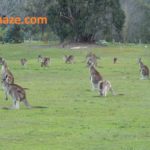
Tidbinbilla snap shot:

Distance: 2 – 15km.
Where: Tidbinbilla, ACT.
Difficulty: Easy, Medium and hard tracks.
Rating: 5 Stars. 
Murrumbigee River

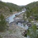
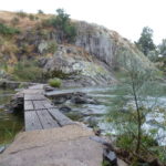
Murrumbigee River

Distance: 3 – 27km.
Where: Kambah Pool, ACT.
Difficulty: Easy, Medium and hard tracks.
Rating: 5 Stars. 
Lake Ginninderra

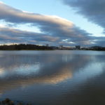
Lake Ginninderra Snapshot:

Distance: 7.3km
Where: Belconnen, ACT
Difficulty: Easy.
Rating: 4 Stars.

Read More ->

Granite Tors, ACT

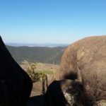
Granite Tors, ACT

Distance: 8.5km
Where: Namadgi, ACT
Difficulty: Hard.
Rating: 4 Stars.

Read More ->

Booroomba Rocks, ACT

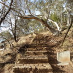
Booroomba Rocks, ACT

Distance: 2.6km
Where: Namadgi, ACT
Difficulty: Medium.
Rating: 5 Stars.

Read More ->

Mt Taylor, ACT

Mt Taylor, ACT

Distance: 3.8km
Where: Kambah, ACT
Difficulty: Medium.
Rating: 4 Stars.

Read More ->

Kokoda Trail, ACT

Kokoda Trail, ACT

Distance: 4.5km
Where: War Memorial, ACT
Difficulty: Medium.
Rating: 4 Stars.

Read More ->

Jerrabomberra Wetlands, ACT

Jerrabomberra Wetlands.

Distance: 4.2km loop
Where: Fyshwick, ACT
Difficulty: Easy.
Rating: 4 Stars.

Read More ->

Black Mountain, ACT

Black Mountain, ACT

Distance: 5km
Where: Black Mountain, ACT
Difficulty: Medium.
Rating: 4 Stars.

Read More ->

Export as KML for Google Earth/Google MapsOpen standalone map in fullscreen modeCreate QR code image for standalone map in fullscreen modeExport as GeoJSONExport as GeoRSS
Mountain Bike Trails, ACT

loading map - please wait...

Stromlo Forest Park: -35.319432, 149.024840
Bruce Ridge: -35.256284, 149.099871
Tidbinbilla: -35.440940, 148.927286
Sparrow Hill: -35.324979, 149.348708
Majura Pines: -35.240851, 149.195819
Tuggeranong Pines: -35.431547, 149.132388
Lake Ginninderra: -35.235910, 149.069495
Shepherds Lookout: -35.245199, 148.980703
Murrumbidgee Discovery Track: -35.396046, 149.012387
One Tree Hill: -35.166441, 149.070826
Murrumbidgee Discovery Track: -35.396185, 149.014999
Granite Tors: -35.628388, 148.956175
Booroomba Rocks, ACT: -35.567212, 148.992548
Mt Taylor, ACT: -35.379603, 149.076362
Kokoda Trail.: -35.280600, 149.149000
Jerrabomberra Wetlands: -35.313224, 149.162548
Black Mountain: -35.278077, 149.098604
Canberra Centenary Trail: -35.241289, 149.073327
marker icon
Get directions Open standalone map in fullscreen mode Export as KML for Google Earth/Google Maps
Stromlo Forest Park

Stromlo Forest Park

Stromlo Forrest Park snap shot:
Distance: 6 loops, 20 – 90 min.
Where: Uriarra Road, Stromlo.
Difficulty: Easy, Medium and hard tracks.
Rating: 5 Stars. Easily top ten mountain bike rides.

Stromlo Forest Park, Stromlo, Australian Capital Territory, Australia
marker icon
Get directions Open standalone map in fullscreen mode Export as KML for Google Earth/Google Maps
Bruce Ridge

Bruce Ridge, Mountain Bike trails:

Bruce Ridge Mountain Bike ride snapshot:
Distance: 20+km loop trails.
Where: .
Difficulty: Medium/Advanced.
Rating: 4 Stars

Bruce Ridge Nature Reserve, Bruce, Australian Capital Territory, Australia
marker icon
Get directions Open standalone map in fullscreen mode Export as KML for Google Earth/Google Maps
Tidbinbilla

Tidbinbilla Nature Reserve.

Tidbinbilla snap shot:
Distance: 20+km.
Where: Tidbinbilla, ACT.
Difficulty: Easy, Medium and hard tracks.
Rating: 4 Stars.

Tidbinbilla Nature Reserve Australian Capital Territory, Australia
marker icon
Get directions Open standalone map in fullscreen mode Export as KML for Google Earth/Google Maps
Sparrow Hill

Sparrow Hill MTB ride

Sparrow Hill Mountain Bike ride snapshot:
Distance: Multiple loops, 5km, 11km, 16km, 40km loop trails.
Where: Sparrow Hill Rd, Kowen, ACT.
Difficulty: Medium. Some advanced bits.
Rating: 4 Stars

Sparrow Hill Road Australian Capital Territory, Australia
marker icon
Get directions Open standalone map in fullscreen mode Export as KML for Google Earth/Google Maps
Majura Pines

Majura Pines Mountain bike trails.

Majua Pines, ACT Mountain Bike ride snapshot:
Distance: 20km.
Where: Majura Rd, Glenlyle.
Difficulty: Beginners, Intermediate and Advanced.
Rating: 5 Stars

marker icon
Get directions Open standalone map in fullscreen mode Export as KML for Google Earth/Google Maps
Tuggeranong Pines

Tuggeranong Pines Mountain bike trails

Tuggeranong Pines Mountain bike trails snapshot:
Distance: About 15km.
Where: Tuggeranong, ACT.
Difficulty: Advanced.
Rating: 4 Stars

174 Old Tuggeranong Road, Australia
marker icon
Get directions Open standalone map in fullscreen mode Export as KML for Google Earth/Google Maps
Lake Ginninderra
Lake Ginninderra.

Lake Ginninderra Snapshot:
Distance: 7.3 km loop.
Where: Belconnen, ACT.
Difficulty: Easy.
Rating: 4 Starts.


lake ginninderra belconnen
marker icon
Get directions Open standalone map in fullscreen mode Export as KML for Google Earth/Google Maps
Shepherds Lookout
Shepherds Lookout.

Shepherds Lookout Snapshot:

Distance: 8km return.
Where: Stockdill Drive, Holt.
Difficulty: Medium.
Rating: 5 Stars.


Shepherd's Lookout walking track, Acton (Act), Australia
marker icon
Get directions Open standalone map in fullscreen mode Export as KML for Google Earth/Google Maps
Murrumbidgee Discovery Track

Murrumbidgee Discovery Track.

Murrumbidgee discovery track snapshot:

Distance: 28km return.
Where: Kambah Pool.
Difficulty: Medium.
Rating: 5 Stars

Kambah pool Road Australian Capital Territory, Australia
marker icon
Get directions Open standalone map in fullscreen mode Export as KML for Google Earth/Google Maps
One Tree Hill

One Tree Hill.

One Tree Hill snapshot:
Distance: 17km one way.
Where: Hall, ACT.
Difficulty: Intermediate.
Rating: 5 Stars

District of Gungahlin Australian Capital Territory, Australia
marker icon
Get directions Open standalone map in fullscreen mode Export as KML for Google Earth/Google Maps
Murrumbidgee Discovery Track

Murrumbidgee Discovery Track.

Murrumbidgee Discovery Track Snapshot:

Distance: 3 - 27km one way.
Where: Kambah Pool, ACT.
Difficulty: Medium/Hard.
Rating: 5 Stars

Pine Island road, Australian Capital Territory, Australia
marker icon
Get directions Open standalone map in fullscreen mode Export as KML for Google Earth/Google Maps
Granite Tors

Granite Tors Bushwalk.

Granite Tors snapshot:

Distance: 8.5km
Where: Namadgi, ACT
Difficulty: Hard.
Rating: 4 Stars.

Orroral Tracking Station, Australia
marker icon
Get directions Open standalone map in fullscreen mode Export as KML for Google Earth/Google Maps
Booroomba Rocks, ACT

Booroomba Rocks, ACT.

Booroomba Rocks Snapshot:

Distance: 2.6km or 11km.
Where: Namadgi National Park, ACT
Difficulty: Medium.
Rating: 5 Stars.

National Library of Australia Parkes Place, Canberra ACT 2600, Parkes, Australia
marker icon
Get directions Open standalone map in fullscreen mode Export as KML for Google Earth/Google Maps
Mt Taylor, ACT

Mount Taylor, ACT.

Mt Taylor snapshot:

Distance: 3.8km return.
Where: Sulwood Dr, Kambah, ACT
Difficulty: Medium.
Rating: 4 Stars.

Sulwood Drive Australian Capital Territory, Australia
marker icon
Get directions Open standalone map in fullscreen mode Export as KML for Google Earth/Google Maps
Kokoda Trail.

Kokoda Trail.

Kokoda Trail bushwalk snapshot:

Distance: 4.5km return.
Where: War Memorial, ACT.
Difficulty: Medium.
Rating: 4 Stars

Australian War Memorial Australian Capital Territory, Australia
marker icon
Get directions Open standalone map in fullscreen mode Export as KML for Google Earth/Google Maps
Jerrabomberra Wetlands

Jerrabomberra Wetlands.

Jerrabomberra Wetlands. snapshot:
Distance: 4.2km loop.
Where: Jerrabomberra Wetlands.
Difficulty: Easy.
Rating: 4 Stars

Dairy Road Australian Capital Territory, Australia
marker icon
Get directions Open standalone map in fullscreen mode Export as KML for Google Earth/Google Maps
Black Mountain

Black Mountain.

Distance: 5km

Difficultly: Easy/Medium.

Rating: 4 Stars

black mountain drive, Acton, ACT, Australia
marker icon
Get directions Open standalone map in fullscreen mode Export as KML for Google Earth/Google Maps
Canberra Centenary Trail

Canberra Centenary Trail.


emu bank avenue, belconnen, act, australia


Tags:

ACT bushwalks, Canberra bushwalks, best bushwalks in Canberra, hike, trek, trails, track.