Sydney – South
Mountain Bike trails south of Sydney.
There are numerous places south of Sydney that offers some excellent mountain biking. Below is a list of some excellent MTB rides:
- Eagle Rock, Royal National Park.
- Heathcote National Park.
- Little Marley, Royal National Park.
- Royal National Park mountain bike loop.
- Woronora Pipeline.
Below is a list of the editors highlights, just click on the image to take you to that web page:

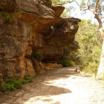
Eagle Rock, Royal National Park Distance: 9km return |
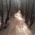
Lady Carrington Drive, Royal National Park Distance: 20km return |
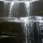 Uloola Falls, Royal National Park |

Woronora Pipeline/Dam Ride Distance: 24km return |
Little Marley, Royal National Park Distance: 15km return |
Royal National Park Distance: 30+km return |
loading map - please wait...
TAGS
Mountain Bike, MTB, bicycle, track, trail, bush, dirt, ride, Sydney, South, Royal National Park.