Clover Hill
Clover Hill Bushwalk.
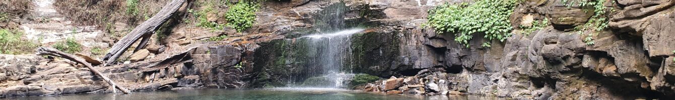
Clover Hill bushwalk trail snap shots:
Distance: 15km or 6km options
Where: Bottom of Macquarie Pass, NSW.
Difficulty: Hard.
Rating: 5 Stars
-
Clover Hill Bushwalk.

Clover Hill Trail on Macquarie Pass
Clover Hill bushwalk has a 6km and 15km return bushwalking options. For the 15km hike start at the bottom of Macquarie Pass. For the shorter 6km walk the trail head starts in the Clover Hill car-park. The Clover Hill trail is a challenging hike and extremely rewarding finishing up at the beautiful rainbow falls. The walk takes you through rain forest filled with giant Red Cedar trees. These beasts are spectacular. It’s a shame they where so heavily logged in the Illawarra region. This walk does give you a glimpse of what the area would have looked like before European settlement.
Make sure you have the track mapped out before you go as it’s very easy to lose it. There are some markers to show you the way so keep your eye out. Getting to rainbow falls does require a bit of a scramble. There maybe a better route then the one I took but I couldn’t find it and had to scramble.
This walk should only be done by experienced hikers with good fitness levels. I Highly recommend it. Get down there and check it out.
Directions to Clover Hill trail.
Google Map Link. The trail head for the Clover Hill bushwalk is at the bottom of Macquarie Pass. If your looking up at Macquarie Pass trail is on the right.
Google Map Link. For the shorter 6km return walk park at the Clover Hill car-park.
-
Clover Hill Trail Map.
 Clover Hill
loading map - please wait...
- Submit your reviewTrail MazeAverage rating: 0 reviews
-
Clover Hill hike Photo Gallery.
-
Clover Hill Youtube Clip.
-
Directions to Clover Hill trail.
Google Map Link. The trail head for the Clover Hill bushwalk is at the bottom of Macquarie Pass. If your looking up at Macquarie Pass trail is on the right.
Google Map Link. For the shorter 6km return walk park at the Clover Hill car-park.
Below is a map of the area:
Tags:
Clover Hill bushwalk, Clover Hill hike, macquarie pass bushwalks, macquarie pass hikes, illawarra bushwalks.